Yesterday, we were finally able to go to the river for a test run. With fishing gear in tow, three friends and I headed down to the Locust Fork at Buckshort Bridge in Mount Olive. We had no success fishing, and so began to find other valuable uses for the kayaks. So while none of this video may be life-changing, perhaps it will serve to show the success of my modification and evidence how to go about jumping from a kayak.
For some time, I and my paddling cohorts have made great use of my Flip UltraHD Video Camera
and its Flip Video Underwater Case
while on the water. This is my second such Flip, because the first one is still probably at the bottom of the Mulberry Fork somewhere, or perhaps is made its way down to the Gulf by now.
But there has long been a limitation...recording while paddling is very problematic. We overcame this obstacle a couple different times, but only in a limited fashion.
In March at Kings Bend by wedging the camera between Tyler's life-jacket, as can be seen beginning at the 8:30 mark in this video
And most recently at the Hargrove Shoals, where I can be seen to be dumped out of my boat, beginning at 1:24 in the video below.
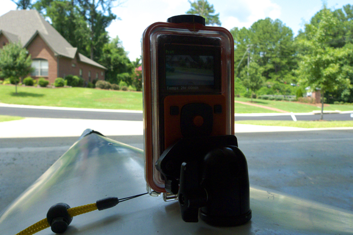
Well as I saw it, there were a couple of ways to rectify the situation. I could buy a helmet cam, which would, of course, be the best and most practical way to go. However, it's not the most economical. So I thought up a way to make a mount, though it did require me to risk ruining my underwater housing for my Flip and drilling a hole in my kayak. But sometimes the risk is worth the reward.
So Operation Kayak-Cam commenced...
I was determined to drill the hole for the mount just north of the cockpit, so that the camera will be easily within arms reach, and I'll be able to leash it to the boat. To mount the camera to the boat, I took a lightweight tripod head (Slik SBH-100DQ Ball Head with Quick Release) that I carry on my monopod, and screwed it to boat.
Using the tripod head, should create a stable platform to hold the camera steadily in a fixed position. In addition to the Flip, I drilled a hold in the waterproof housing I built for my Panasonic DMC-LX3, which will give me the opportunity to take still photographs or video.
Now I'm all set to hit the water and give this setup a trial run. Here's hoping it works as well in practice as it appears it will in theory.
With enough summer rain this week to paddle any number of places, yesterday, Tyler and I paddled the Hargrove Shoals section of the Cahaba. This is the primary run from which you can enjoy the Cahaba Lilies from about mid-May to mid-June.
There are three sections of rapids along this run. For the first two, you should remain to the far left, for the best rapids. On the third, stay to the far right. When we ran the river, the Centreville gage was reading about 800cfs and falling quickly. We scraped a bit on shoals, but it was definitely runnable; never had to get out of the boat. The river would be optimal at 1000cfs+.
After the third section of rapids, you'll enter something of a gorge. From this point, the take-out is still more than a mile distant. The gorge is also the end of the national wildlife refuge; you cannot camp within the refuge's boundaries, but are able to anywhere after you enter the gorge section.
After much planning and scouting, on Friday, May 20, several friends and I set about running the Cahaba from the Highway 26-Riverbend Rd put-in in Bibb County to the Cahaba River Historical Park in Centreville. The run was a little over 8 miles by the river, with the plan being to camp on a sandbar off Harrisburg Rd and run the 13 miles from Centreville to Harrisburg Rd on Saturday.
Although the water was low fairly low (about 380cfs according to the Centreville gage), we had a nice paddle on Friday. There was not much current, and we were in no hurry despite our late start. We did the run in a little over 3 1/2 hours, including regular stops along the way. Most of the run is flatwater, but the last two miles or so include regular shoals that can be fun and break up the monotony a bit. We also ran across some bow fishers, who didn't appear to be having any luck.
After finishing the run about 4:30pm, we collected our boats and headed off down Harrisburg Rd to set up camp. Although the Cahaba River Historical Park has some nice camp grounds (which require making a reservation through Centreville City Hall, and a $10 site fee), we were looking for something a bit more secluded. And boy, did we find it!
Where the Cahaba passes under Harrisburg Rd is far removed from any form of civilization. Yet it is not beyond the reach of idle adolescents in possession of spray paint. The Harrisburg Rd bridge bears many names, messages, and pictures, most of which involve the male reproductive organ. We were not deterred by this, though perhaps we ought to have been.
Following some dirt trails almost to the river, we parked and began setting up camp. The tent went up, and shortly thereafter, a fire pit was created along with a precariously-arranged set of bamboo sticks to hold up the grill top. The chicken went on shortly after that, followed by still-husked corn.
With dinner wrapped up, we were beginning to wind down, planning to head to bed early so as to be ready for our long paddle on Saturday morning. The fireflies and frogs were out, but so too were some drunk locals. The Harrisburg bridge was about a quarter mile from our campsite on the sandbar, and we heard a big truck rumble up to the bridge and stop. Doors opened and closed. Voices and flashlights. "Hey, there's somebody on the sandbar!" Then the shouting was directed our way, as were the beams of flashlights, though we were out of reach. A couple of large-ish sounding things were then thrown into the river. Truck doors open and close again. The loud loping sound of a V-8 commences, and then the truck is riding around somewhere out of sight but behind us. It was then that my cowardice prevailed: "Fellas, it's time to go." With a consensus, we began to pull up camp at a much more frenetic pace than it had been set out. Impressively, despite the darkness and hurried state of affairs, we left nothing behind.
With all things properly loaded and battened down, we left bouncing out way through the dirt trails through which we had come. But then...a wrong turn was taken. A truck bottomed out. A gunning engine and low first get it through, but it begins to make a terrible sound. Once we get to the road, we hop out to see what the noise is; the bed has come off the frame, and the wheelwell is rubbing the tire. With some lifting and pushing and pulling, the frame falls back into place. But the truck won't start. The battery cables were jostled loose; nothing a socket wrench and some luck can't handle. Finally, we're off, and this before our hillbilly cohorts return to harass some campers on the sandbar, or perhaps with more malevolent intentions.
With no other real options available, we made the long trek home. The paddling trip of the following day, postponed for the indefinite future.
For the second year in a row, I planned a camping and paddling trip to take place on the Locust Fork of the Warrior River during Spring Break. Last year's trip was nearly a total disaster ("nearly," only in that we all survived in-tact). I immediately knew this trip would prove more successful when we arrived at the right river. Last year, I got confused which direction to turn on County Road 26; so instead of putting in on the Locust Fork (on right), we put in on the Mulberry Fork (on left).
Unfortunately (or perhaps, in the end, it was fortuitous) that stretch of the Mulberry has some whitewater; additionally, the river was pretty high because of recent rainfall, both of which we were unprepared for. Three people in a sixteen foot canoe, laden with food and drink enough to last us the whole of our two-day camping trip.
Within twenty minutes of putting in, we hit our first set of rapids. Since I was at the front of the boat, I could see that it wasn't going to go well for us, so I got as low as I could in the floor of the bow. Gallons of icy water poured into the bad as we hit the first wave. This made us even heavier, so that we were sitting lower and took on even more water after hitting the second. We didn't hid the third wave so much as blunder into it; at this point the canoe was essentially submerged. We were still sitting in it, but even the gunwales were entirely underwater. Then we hit a rock and were dumped out along with all of our belongings. Daniel was thrown clear of the boat and could be heard laughing hysterically, some twenty or thirty feet from Matt and myself. I scrambled to swim toward the watertight box containing our phones, GPS, and other essentials. Matt had the foresight to grab the boat. Most of our food was lost, as was my Flip camcorder, my lifejacket (which I wasn't wearing, of course), and an oar.
After we were able to beach the boat, after being driven downriver for a while, we were able to begin to collect our bearings. Everyone's limbs were still in tact. We were down to one oar. I was pretty certain we were on the river, and now had no idea what was ahead of us. We were in the middle of nowhere and had no choice but to carry on. Once we mustered the courage to re-embark, we began to come across some of our orphaned belongings: a bag of bananas, a cooler with our water and sandwiches, and here-and-there oatmeal creme pies.
Finally, we came upon civilization, a farm house atop a bluff - our salvation. We beached the canoe, called it a day, and ended the trip effective immediately.
This is the only photo I have to show for the trip - Canon Rebel 2000, EF 28-80 3.5-5.6 III
But that was last year. This year, I ended up in the water much more quickly, but at least I was in the right river. And since I didn't lose my Flip this time, I'll let the video tell its own story of our trip.
But here are a couple of the better photographs, since this is supposed to be a photoblog and all.
Sunrise at Kings Bend - Panasonic LX3
Panasonic LX3
Panasonic LX3
For more information about the North Jefferson Kayak Club and its activities,
visit our website and/or our Facebook page.
As the mercury in the thermometer begins to rise and the rains begin to fall, it was time to hit the water again. Whereas last year, we spent most of our time on the Locust Fork, we want to establish ourselves as equal opportunity paddlers so...off we went to the Cahaba.
We paddled the stretch of the Cahaba River from Hwy 280 to Lorna Road, about 11.25 miles. Thanks to some current pushing us, we were able to do this run in four hours, and that with some out-of-boat sidetracking.
We were using this trip as practice for our upcoming paddling and camping trip on the Locust Fork. For more information about paddling opportunities in Alabama visit the North Jefferson Kayak Club website.
All of these photos are still-frames lifted from video shot with my handy-dandy Flip.

 and Underwater Case
 to my kayak.